Do You Need a Car in Louisiana?
Do you need a car for a trip built around New Orleans?
No, not inside the city: the French Quarter is walkable and the RTA streetcars and buses cover the rest. You need a car, or an organised tour, only once you leave the city for the plantations, the swamps, Lafayette or the Gulf Coast, since none of them have useful public transport.
The one decision to make before anything else
Before booking a hotel, an itinerary or a single activity, most visitors to Louisiana face one practical question that shapes everything else: do you actually need a car? The honest answer is that it depends entirely on where in this guide’s territory you plan to spend your time. Inside New Orleans itself, a car is close to a liability. Outside it, once plantations, bayous, Cajun Country or the Gulf Coast enter the plan, a car, or its substitute, an organised tour, becomes close to essential. This page sets out that boundary once, clearly, so the rest of the site does not have to repeat it every time it covers a neighbourhood, a day trip or an activity.
This is not a review of any particular streetcar line, swamp tour operator or rental agency. Those comparisons live on their own pages, linked below. What follows is the framework: when walking and public transport are simply enough, and when the geography of southern Louisiana forces the issue.
The geography behind the rule
The reason this question even has a clean answer is the shape of the land itself. New Orleans sits on a bend of the Mississippi River, in the far south of Louisiana, roughly 160 kilometres upstream from the Gulf of Mexico. It is not the state capital, and it is not on the coast: Baton Rouge holds that role, about 130 kilometres further upriver, and the city itself is wedged between the river and Lake Pontchartrain, a large lake crossed by the Causeway to the north shore. Much of New Orleans sits at or below sea level, held dry by levees and pumps rather than by elevation.
Almost everything this site covers lies within a two-hour drive of the French Quarter: the plantation country of the River Road, the swamps and bayous to the south and west, Cajun Louisiana around Lafayette, and the Mississippi Gulf Coast. That compactness is exactly why the car question has a binary answer rather than a mushy one. Inside the historic core, the river-and-lake geometry that makes New Orleans distinctive also makes it walkable, because the oldest neighbourhoods were built at a pedestrian scale long before the road network around them existed. Step outside that core, and the same geography, spread-out plantations, isolated bayou communities, a state capital and a coastline that are each a discrete drive away, means there is no single transit line that could plausibly connect them.
Inside New Orleans: a car works against you
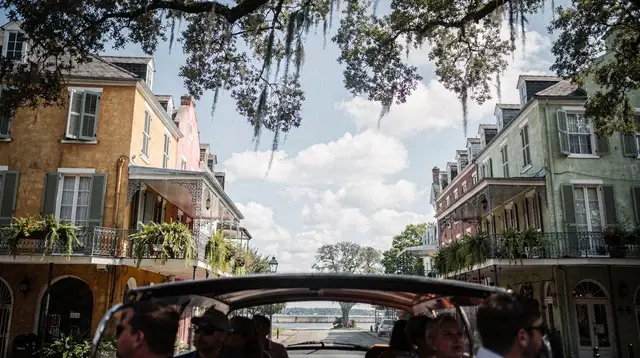
The French Quarter is the heart of most New Orleans trips, and it was laid out long before cars existed. The historic grid runs roughly thirteen blocks by six, from Jackson Square and St Louis Cathedral down to the French Market and Decatur Street. At that scale, walking is not just possible, it is faster than driving, because there is nowhere to park once you arrive. Street parking in the Quarter is metered, in short supply, and enforced with tow-away rules that visitors underestimate at their cost. A car parked for a day in the Quarter is money spent for nothing gained.
The same logic extends a little further, to the Garden District along St Charles Avenue, to Treme just north of the Quarter, and to the Faubourg Marigny and Bywater downriver where Frenchmen Street runs. None of these require a car either, because the RTA network was built to connect exactly this stretch of the city.
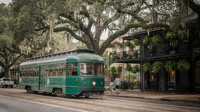
The RTA runs four streetcar lines: St Charles, the oldest continuously operating street railway in the world, Canal Street, Riverfront, and Rampart-St Claude, backed up by a citywide bus network. A Jazzy Pass covers a day or several at a flat cost, and tickets can be bought and validated from a phone app, so there is no need to carry exact change. For a full walkthrough of routes, fares and which line goes where, see Getting Around New Orleans by Streetcar.
One water crossing rounds out the picture: the Canal Street ferry, which carries pedestrians and cars across the Mississippi to Algiers Point, a quiet, low-key neighbourhood that rewards a short detour without ever requiring you to drive there.
Ride-hailing apps are widely available across the city and fill the remaining gaps, whether that is a late-night return from Frenchmen Street or a trip out to Mid-City for the New Orleans Museum of Art and the Besthoff Sculpture Garden in City Park. Between walking, the streetcars, the ferry and ride-hailing, a visitor who never leaves New Orleans itself has no real reason to rent a car. For the airport leg specifically, which sits outside this walkable core, see the dedicated comparison of shuttle, taxi and bus options.
Where the city’s transport stops working
The boundary is geographic, not a matter of preference. Everything this site covers beyond central New Orleans, the River Road plantations, the swamps and bayous, Cajun Country around Lafayette, and the Mississippi Gulf Coast, sits outside the RTA’s reach entirely. There is no streetcar line to Oak Alley, no city bus to the Barataria Preserve, no practical way to reach Breaux Bridge on public transport.
Amtrak does serve New Orleans, from Union Passenger Terminal, with three long-distance routes: the City of New Orleans north to Chicago, the Crescent east to New York, and the Sunset Limited running west. These are legitimate ways to arrive in or leave the city, but they are slow, infrequent, and not built for hopping off at a plantation or a bayou town for an afternoon. They do not solve the day-trip problem.
That leaves two realistic options once you plan to leave the city: a self-drive rental car, or an organised tour that includes hotel pick-up and drop-off. Both work, and the right choice usually comes down to how many out-of-town stops you have in mind and how much you want to manage the driving yourself.
Rental car or organised tour: how to choose
A rental car earns its cost when you have more than one out-of-town destination to string together, or when you want to set your own pace rather than a tour bus’s schedule. Renting for a few days, rather than the whole trip, avoids paying for a car that then sits unused and unparkable in the Quarter.
A single loop up the River Road, for instance, taking in Oak Alley Plantation, Laura Plantation and the Whitney Plantation in one day, is entirely manageable by car, with the added flexibility of choosing your own order and pace between sites. The same applies to a swamp excursion combined with a stop in Des Allemands or Kraemer on the way back, or a longer push out to Lafayette and Cajun Country, roughly two hours fifteen minutes west, where a car makes the difference between one stop and several.
An organised tour makes more sense for a single, well-defined outing, particularly the swamp and bayou tours, which typically depart from a fixed dock, or a single-plantation visit where round-trip transport from a New Orleans hotel is already built into the ticket. It also suits visitors who would rather not drive on unfamiliar rural roads, or who are travelling without a second driver to share the trip. The trade-off is schedule: a tour runs when it runs, and covers only what it is built to cover, whereas a rental car covers whatever you decide that morning.
For a broader look at what a first visit to New Orleans should prioritise, day trips included, start with New Orleans for First-Time Visitors; for the day trips themselves, Plantations Along River Road Compared and Swamp Tours Compared: Airboat vs Boat set out the operator-level choices this page deliberately leaves aside.
a guided city tour of New Orleans that covers the main sights without any driving on your part is a reasonable way to get oriented in the first day or two, before deciding whether the rest of the trip needs a car at all. Visitors who would rather keep that first orientation to a smaller group can look at a smaller-group city tour that covers the same historic ground instead, again with no driving required.
What driving actually involves, once you leave the city
For visitors used to driving at home, Louisiana itself is not the hard part. Traffic keeps to the right, distances and speed limits are posted in miles, and the interstates connecting New Orleans to its day-trip territory, principally I-10 running east-west and the roads north across the Causeway, are straightforward, well-signed highways rather than anything requiring local knowledge. Fuel and rest stops are frequent along the interstates, less so on the smaller parish roads that lead into bayou country, so it is worth filling up before turning off onto the back roads toward somewhere like Kraemer or Des Allemands.
Two seasonal factors are worth planning around rather than worrying about. Summer thunderstorms build quickly and heavily in the afternoons and can slow driving for an hour or so before clearing; they rarely cancel a day outright, but they are worth allowing for if a swamp tour or plantation visit has a fixed departure time. Hurricane season, which affects the wider Gulf Coast region, can occasionally disrupt travel plans and, in a worst case, prompt evacuation traffic on the interstates leading out of the city; it is a real, if infrequent, consideration for anyone driving themselves rather than relying on a tour operator to make that call.
Baton Rouge and the Gulf Coast: the two edges of the map
The River Road is not the only route that ends at Baton Rouge. As the state capital, with its art-deco State Capitol and the USS Kidd, it sits at the top of the plantation road and is reachable either as the final stop on a River Road loop or as a standalone day trip; either way, it is another destination with no practical bus or rail link from New Orleans, so the same rental-car-or-tour choice applies.
In the other direction, the Mississippi Gulf Coast, towns such as Bay St Louis, Pass Christian, Gulfport and Biloxi, sits roughly an hour to an hour and a half east along the interstate. It is the one part of this site’s territory that actually touches the coast, since New Orleans itself does not, and it is reached the same way as everywhere else outside the city: self-drive or organised tour, with no meaningful public transport alternative in between.
A quick reference
| Where you’re going | Best way to get there | Car needed? |
|---|---|---|
| French Quarter | Walking | No |
| Garden District, Treme, Marigny, Bywater | Walking, streetcar, bus | No |
| Algiers Point | Canal Street ferry | No |
| Airport (MSY) to French Quarter | Shuttle, taxi, ride-hailing, RTA 202 bus | No |
| River Road plantations | Rental car or tour with pick-up | Only without a tour |
| Swamp and bayou tours | Rental car or tour with pick-up | Only without a tour |
| Lafayette and Cajun Country | Rental car | Effectively yes |
| Mississippi Gulf Coast | Rental car or tour | Only without a tour |
| Baton Rouge | Rental car or tour | Only without a tour |
If your trip mixes several of the out-of-town rows above, renting for those specific days, and leaving the car behind or returning it before heading back into the Quarter, is usually the most cost-effective approach. If you plan to add several stops over a few days, a multi-attraction pass that bundles several New Orleans experiences together can also simplify the in-city portion of the trip, freeing your budget and planning time for whichever out-of-town route needs a car or a tour.
FAQ: car vs no car in Louisiana
Can I get around New Orleans without a car?
Yes, easily. The French Quarter is a compact grid of roughly thirteen by six blocks, best covered on foot, and the RTA streetcar and bus network, plus the Canal Street ferry, reach the Garden District, Mid-City, the CBD and Algiers Point.
Is it hard to park in the French Quarter?
Yes. Street parking in the Quarter is metered, limited and tightly enforced, and tow-away rules are strict, so a rental car mostly sits idle and costs money while you are inside the city.
How do I get from the plantations, swamps or Lafayette back to New Orleans by public transport?
You mostly cannot. There is no practical bus or rail network linking these areas to the city, so the only realistic options are a self-drive rental car or an organised tour with hotel pick-up and drop-off.
Does Amtrak cover day trips from New Orleans?
Not usefully. Amtrak’s City of New Orleans, Crescent and Sunset Limited routes run from Union Passenger Terminal, but they are infrequent long-distance trains, not a way to reach the plantations, the swamps or the Gulf Coast for a day.
Should I rent a car for the whole trip or just for part of it?
Most visitors do better renting for only the days they leave the city, since a car is a liability in the Quarter but the only flexible way to string together several out-of-town stops such as the River Road and Cajun Country.
Are organised tours a real alternative to renting a car?
Yes, especially for a single destination like Oak Alley or a swamp tour, since most operators include round-trip transport from a New Orleans hotel, which removes the need to drive or find parking altogether.
Is driving in Louisiana difficult for visitors?
No. Traffic drives on the right, distances and speed limits are posted in miles, and roads outside the city are generally straightforward, though summer thunderstorms and, in hurricane season, evacuation traffic are worth watching.
Getting around New Orleans on GetYourGuide
Verified deep-linked GetYourGuide tours. Book through these links and we earn a small commission at no cost to you.
GetYourGuide does not provide a product photo for this activity — the image shows the meeting point, photographed by us.