A city in a river bend, not on the coast
New Orleans is a city in the US state of Louisiana, built on a broad curve of the Mississippi River in the far south of the country, roughly 160 km upstream from where the river meets the Gulf of Mexico. It is the state’s largest and best-known city, and for most visitors it is also the reason the rest of southern Louisiana gets explored at all — but it is worth clearing up two things before going any further.
First, New Orleans is not on the coast. The city sits inland, wedged between the Mississippi River on one side and Lake Pontchartrain, a large brackish lake crossed by the Causeway bridge, on the other. The Gulf beaches and casinos of Biloxi and Gulfport are a separate destination, reached by a drive of an hour to ninety minutes east along the Mississippi Gulf Coast.
Second, and more commonly confused, New Orleans is not the capital of Louisiana. That is Baton Rouge, roughly 130 km upriver, with its art-deco state capitol building and not much reason for most travellers to detour there unless they are working through the River Road on the way. New Orleans is the state’s cultural and economic centre, but political power sits upstream.
Below the water, protected by engineering
Much of New Orleans lies at or below sea level, a consequence of building a city on reclaimed marsh and swamp in the Mississippi delta. The only reason the city stays dry is a continuous system of levees, floodwalls and pumping stations, engineered over more than a century. That system is not a piece of historical trivia: it failed catastrophically when Hurricane Katrina struck on 29 August 2005.
The disaster that followed was primarily a levee failure, not the storm surge alone, and it flooded roughly 80% of the city, hitting the Lower Ninth Ward, Lakeview and New Orleans East hardest. Katrina remains a living subject for residents, not sightseeing material, and it is worth understanding as context for how the city is built and maintained rather than treating it as an attraction in itself.
The practical upshot for visitors is simpler: New Orleans is flat, humid, and shaped by water on every side. The Mississippi curves past the French Quarter close enough that the riverfront is a five-minute walk from Jackson Square, while Lake Pontchartrain lies a short drive north through Mid-City.
Parishes, not counties
Louisiana is the only US state divided into parishes rather than counties, and it is also the only state whose legal system descends from civil law rather than English common law — both legacies of French and Spanish colonial rule. New Orleans occupies Orleans Parish, a compact unit that essentially is the city itself, unlike most American cities, which sprawl across multiple counties. This matters mostly for context: local news, court records and some tourism material will refer to “the parish” rather than “the city,” and it is the same thing.
Getting in: MSY airport
Louis Armstrong New Orleans International Airport, known by its code MSY, sits in the suburb of Kenner, about 18 km west of the French Quarter. There is no rail or metro connection between the airport and the city — a detail that surprises visitors used to European or Asian airport transit. The realistic options are a flat-fare taxi, a ride-hailing app, a shared shuttle van, or the RTA route 202 airport bus, which is cheap but slow and not built for travellers with a lot of luggage. Whichever option is chosen, budget 25 to 40 minutes depending on traffic. For a full breakdown of fares and timing, see the dedicated guide on getting from MSY airport to the French Quarter.
Amtrak also serves the city, from Union Passenger Terminal, with long-distance trains toward Chicago, New York and westward — but the services are slow and infrequent, and nobody uses them to get around Louisiana day to day. Everything outside the city itself, from the plantations to the swamps to Cajun Country, is reached by road.
The shape of the city, in outline
This page is deliberately the wide-angle view. The two neighbourhoods that draw the most attention — the French Quarter and the Garden District — each have their own dedicated guide to their streets, landmarks and walking routes, and this page won’t try to repeat that detail. What follows is the map of how the pieces fit together.
The French Quarter, or Vieux Carré, is the oldest neighbourhood, laid out in a tight grid around Jackson Square, St Louis Cathedral and the French Market. It is compact enough — roughly 13 blocks by 6 — to walk end to end, and it is where most first-time visitors base themselves. For a street-by-street orientation before arriving, the French Quarter walking guide is the natural next stop.
Just north of the Quarter, Tremé is one of the oldest African American neighbourhoods in the country and a genuine birthplace of the city’s music tradition, centred on Louis Armstrong Park and Congo Square. Downriver from the Quarter, the Faubourg Marigny and Bywater are where Frenchmen Street runs — the live-music strip that locals, rather than tour guides, tend to recommend. The contrast between that street and Bourbon Street is worth understanding before choosing where to spend an evening; see Frenchmen Street versus Bourbon Street for the difference in tone.
Uptown, along the streetcar line on St Charles Avenue, sit the Garden District and Lower Garden District, with their antebellum mansions and the above-ground tombs of Lafayette Cemetery No. 1 — full detail in the Garden District and streetcar guide. Mid-City holds City Park and the New Orleans Museum of Art, the Central Business District and Warehouse Arts District hold the National WWII Museum, and Algiers Point, reached by ferry across the river, offers a quieter, residential view back toward the skyline.
The city’s cemeteries deserve a specific note. Their above-ground tombs — a response to the same high water table that requires the levees and pumps — are one of New Orleans’s most recognisable images, but access is restricted: St Louis Cemetery No. 1 can only be visited with an authorised guide, and rules at other cemeteries change, so it is worth checking current access before planning a visit. The cemeteries of New Orleans visitor guide covers what’s open and how.
Getting around once you’re here
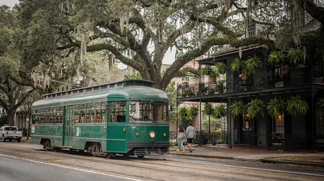
Inside the city, the RTA operates four streetcar lines — St Charles, Canal Street, Riverfront and Rampart–St Claude — plus a wider bus network, all covered by a day or multi-day Jazzy Pass. The St Charles line, which runs through the Garden District, is the oldest continuously operating street railway in the world. The guide to getting around by streetcar has route details and fares.
The French Quarter itself is best explored on foot; its grid is small enough that a car adds nothing but parking headaches, and parking in the Quarter is both difficult and strictly enforced. A short ferry ride across the Mississippi connects Canal Street to Algiers Point. Ride-hailing apps cover everything the streetcars don’t reach.
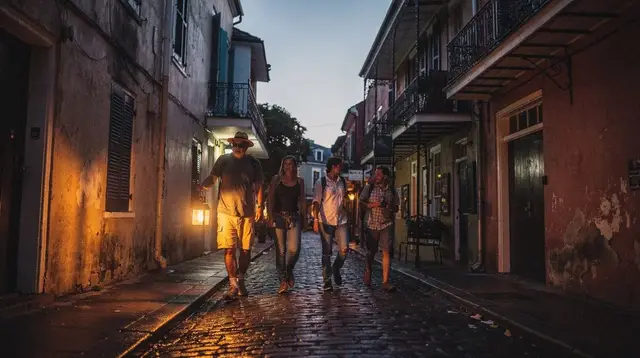
Two useful walking-focused ways to see the historic core are guided city tours and self-directed routes — the guided versus self-guided French Quarter comparison lays out the trade-offs, and evening options range from ghost and cemetery walks to a straightforward pub crawl through the Quarter’s older, allegedly haunted corners. A guided evening pub crawl through the French Quarter’s supposedly haunted bars is one of the most-booked ways to combine the city’s nightlife with its history after dark.
New Orleans also treats Voodoo as a real, still-practised religion with African and Catholic roots rather than a novelty, and it takes cemetery access seriously for the same reason. A guided walking tour through the city’s historic above-ground cemeteries is the only realistic way to see St Louis Cemetery No. 1 up close, and pairing it with a guided introduction to New Orleans Voodoo history gives useful context before wandering Royal Street’s shops on the same subject. Full background sits in the Voodoo in New Orleans guide.
Beyond the city: what a two-hour radius covers
Almost everything this site covers outside the city itself sits within about two hours of the French Quarter, and it is reached by road rather than rail. Upriver, the River Road plantations — including Oak Alley with its quarter-mile canopy of live oaks and the Whitney Plantation, the first US museum built around the perspective of enslaved people — sit 45 minutes to an hour and a half from the city, on the way toward Baton Rouge.
These are sites where enslaved people were held and worked, and the better museums along the road, Whitney above all, tell that history directly rather than treating the architecture as the whole story; the comparison of River Road plantations explains how each one differs in approach.
South and west of the city lie the swamps and bayous, including the Barataria Preserve about 40 minutes away and the Honey Island Swamp near Slidell, both reachable as day trips with airboat or flat-boat operators. Alligators, herons and cypress draped in Spanish moss are the draw, though alligators are far less active in the colder months — see the swamp tour comparison before booking.
Further out, roughly two hours west, Cajun Country around Lafayette is a genuinely different culture from New Orleans — rural, roux-based in its cooking, and home to zydeco and Cajun music rather than jazz. It’s worth repeating: Creole and Cajun are not the same thing, and New Orleans itself is a Creole city, not a Cajun one; the distinction is unpacked fully in Creole versus Cajun food, explained.
Practical basics before you plan further
New Orleans runs on the US dollar, and while cards are accepted almost everywhere, cash still matters for tipping street musicians, guides and drivers, and for some Bourbon and Frenchmen Street bars. Sales tax is added at the till rather than shown in the sticker price, and tipping of 18–20% is expected in restaurants and bars. The legal drinking age is 21, and the city is unusual in allowing open containers on French Quarter streets — in a plastic go-cup, never glass.
Climate is humid subtropical: long, hot, very humid summers with daily thunderstorms, milder winters that can still turn genuinely cold for a few days, and the most comfortable weather in spring (March–May) and autumn (October–November). The Atlantic hurricane season runs from 1 June to 30 November and is a real planning risk, not a certainty — travel insurance is worth having in those months.
Mardi Gras is a movable feast, falling 47 days before Easter and therefore somewhere between early February and early March depending on the year, with the Carnival parade season starting on 6 January; never treat it as a fixed date. Jazz Fest, held across the last weekend of April and first weekend of May, and the French Quarter Festival in mid-April both push hotel prices up sharply and fill the city.
Safety follows ordinary big-city logic: the French Quarter, Garden District and Warehouse District are busy and well-policed, but New Orleans has a higher violent-crime rate than the US average outside the tourist core, so sticking to lit, busy streets at night and taking a ride rather than walking long distances after dark is sensible advice. Tap water is drinkable, and the bigger everyday risks are heat, humidity and mosquitoes, especially on a dusk swamp tour.
For a first visit, the practical order is usually: settle into the French Quarter or nearby, spend a couple of days orienting between the Quarter, the Garden District and Frenchmen Street, then use a spare day for one trip beyond the city — a plantation, a swamp, or the start of a longer Louisiana loop. The three-day New Orleans itinerary and the guide on how many days you actually need both go into that pacing in more detail than fits here.
Frequently asked questions about visiting New Orleans
Is New Orleans the capital of Louisiana?
No. Baton Rouge, roughly 130 km upriver, is the state capital. New Orleans is the state’s largest city and its main tourist gateway, but it has never been the seat of state government.
Is New Orleans on the Gulf Coast?
Not directly. The city sits inland on a bend of the Mississippi River, between the river and Lake Pontchartrain, roughly 160 km upstream from the Gulf of Mexico. The Mississippi Gulf Coast beaches are a separate day trip east of the city.
How do you get from the airport to the French Quarter?
Louis Armstrong New Orleans International Airport (MSY) is in Kenner, about 18 km west of the French Quarter, with no rail or metro link. Taxis, ride-hailing apps, shared shuttles and the RTA 202 airport bus all make the 25–40 minute trip by road.
Why is so much of New Orleans below sea level?
New Orleans was built in the marshy delta between the Mississippi River and Lake Pontchartrain. Much of the city sits at or below sea level and depends on a system of levees and pumps to stay dry, a fact that became catastrophically clear when the federal levee system failed during Hurricane Katrina in 2005.
Is a parish the same as a county?
In practice, yes. Louisiana is the only US state divided into parishes rather than counties, a legacy of its Catholic, French and Spanish colonial past. New Orleans occupies Orleans Parish.
How many days do you need in New Orleans?
Three to four days covers the French Quarter, the Garden District and a first taste of the city’s music and food, with a day left over for one out-of-town trip such as a plantation or a swamp tour. Longer stays allow time for Louisiana’s wider region.
What’s the difference between Creole and Cajun in New Orleans?
New Orleans is a Creole city: its food and culture formed here from French, Spanish, African and Caribbean roots. Cajun culture belongs to the Acadiana region around Lafayette, over two hours west, settled by Acadian exiles in the 1750s. The two are related but not interchangeable.